How do you work in pipeline inspection drones?
The shift toward using unmanned aerial systems, commonly known as drones, for inspecting critical infrastructure like oil and gas pipelines represents a fundamental change in how companies manage safety, cost, and operational continuity. Moving away from traditional, often dangerous, methods such as ground patrols or helicopter flyovers, drones bring a level of precision and accessibility previously unattainable. [1][6] This technology allows inspectors to survey vast, remote, or difficult-to-access stretches of pipeline right-of-way with greater detail and regularity. [2]
# Safety Gains
The primary driver for adopting drone inspection is safety. Traditional methods frequently place personnel in hazardous conditions, requiring them to survey long distances on foot or fly low alongside pipelines in helicopters, which involves inherent risks. [6] By deploying drones, the need for human inspectors to enter dangerous or inaccessible terrain is drastically reduced, keeping personnel out of harm’s way. [1][9] This immediate removal of human exposure to risks associated with patrolling remote, rugged, or high-traffic areas is perhaps the single greatest benefit the technology offers the industry. [6]
# Operational Efficiency
Beyond safety, efficiency gains are substantial. A drone can cover ground much faster than a person on foot, dramatically cutting down inspection time. [2] For instance, comparing a manned helicopter flight that might take days to cover a long segment versus a drone team completing the same route in hours, the time saving is significant. Furthermore, when a potential issue like a slight ground disturbance or vegetation encroachment is identified, the drone can be sent back to that precise GPS coordinate for a follow-up visual inspection immediately, something logistically challenging with crewed aircraft. [2] This rapid response capability means that minor issues can be addressed before they escalate into costly failures. [6]

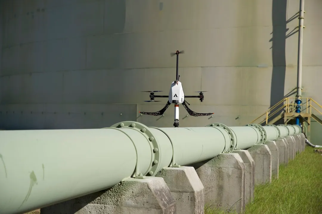
# Inspection Mechanics
Working with pipeline inspection drones is far more involved than simply flying a consumer quadcopter. It requires meticulous planning, specialized equipment, and expert data handling.
# Preflight Planning
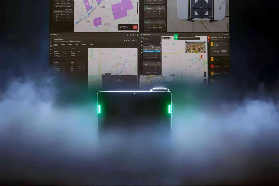
The initial step involves detailed mission planning, which is crucial for successful, compliant operations. [2] This phase requires understanding the pipeline's geography, regulatory airspace restrictions, and the specific data required by the client. [2] Planners must generate detailed flight paths, often using Geographic Information System (GIS) data to map the route precisely. [2] For extremely long stretches, especially in areas where continuous visual line-of-sight (VLOS) flying is impossible or impractical, operators must plan for Beyond Visual Line of Sight (BVLOS) operations, which often involve sophisticated, nested drone systems or require specific regulatory waivers. [5] Proper planning dictates battery life management, data storage capacity, and emergency landing zones along the route. [2]
# Data Acquisition
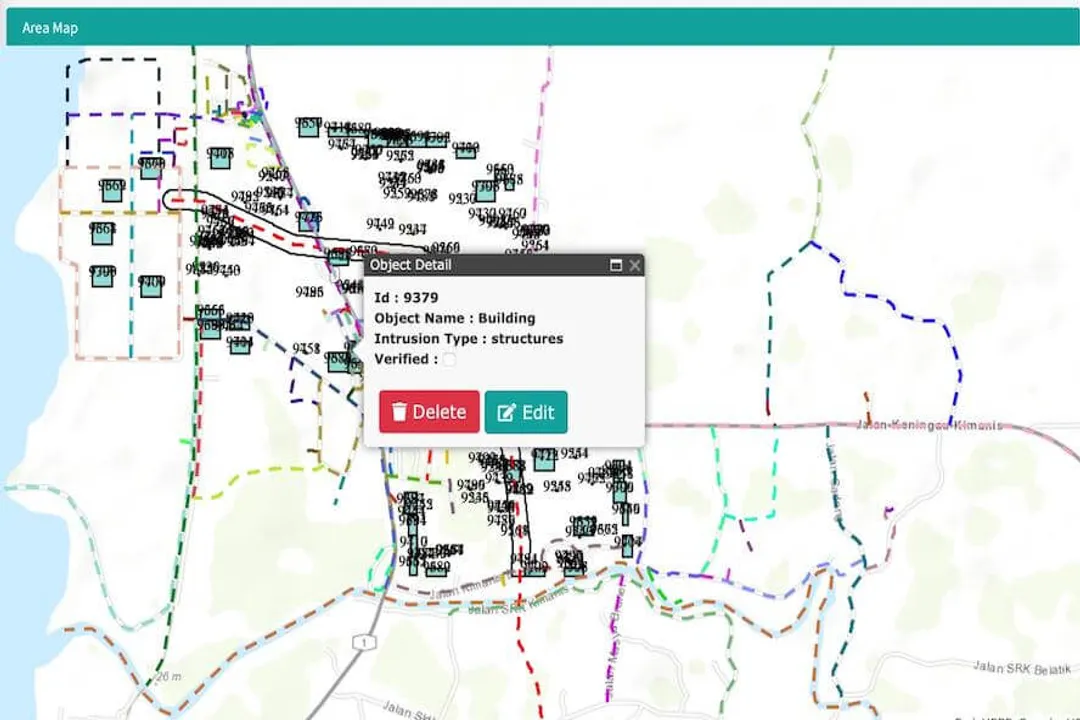
During the flight, the drone acts as a highly mobile sensor platform. The type of sensor deployed dictates the type of defect the team is looking for. Standard visual inspections rely on high-resolution RGB cameras to spot surface anomalies, such as coating damage, evidence of leaks, or unauthorized construction near the right-of-way. [1][2] However, modern inspections often incorporate more advanced tools. Thermal sensors can detect temperature differences indicative of gas or liquid leaks below the surface, while LiDAR can create extremely accurate three-dimensional models of the terrain to monitor ground stability around the pipe. [1] The drone collects this data geo-referenced to the exact location along the pipeline. [2]
# Data Processing
Once the mission is complete, the collected data—which can be terabytes of high-resolution video, still images, or 3D point clouds—must be processed. [2] Specialized software is used to stitch images into orthomosaics or 3D models. [2] This is where many companies see a significant difference between basic aerial photography and true pipeline inspection. For example, sophisticated algorithms can analyze captured imagery to automatically flag areas of interest for human review, such as hairline cracks or subtle color changes indicating seepage. [2] Analyzing this massive dataset efficiently is the bottleneck that separates high-value inspection services from simple aerial photography services.
# Technology Platform
The choice of drone platform is dictated by the mission profile. Industrial-grade drones are necessary for reliability, payload capacity, and flight endurance far exceeding that of hobbyist models. [1]
# Drone Systems
For routine visual inspections, a multirotor drone equipped with a stabilized gimbal carrying a high-zoom camera is standard. [1] In contrast, inspecting thousands of miles of pipeline efficiently necessitates platforms capable of longer flight times. Fixed-wing drones, which are more energy-efficient for long linear routes, can be deployed for broader surveys, sometimes operating alongside multirotor systems used for detailed close-ups of anomalies. [5] This combination, sometimes referred to as a nested system, pairs the long-range endurance of fixed-wing platforms with the vertical takeoff and landing (VTOL) precision of multirotors, making BVLOS inspections feasible for critical infrastructure. [5]
# Sensor Payload
The sensors are arguably more important than the airframe itself. A simple visual camera might suffice for routine right-of-way encroachment checks, but leak detection often requires specific sensors. Thermal imaging, for instance, relies on detecting minute temperature changes caused by escaping product, which requires a highly sensitive camera calibrated for that specific environmental context. [1] A crucial factor in sensor selection is ensuring the data captured aligns with regulatory requirements and the company’s internal integrity management standards. The quality of the data determines the confidence an integrity engineer has in recommending maintenance actions.
One area where standard sources often generalize is the context-sensitivity of sensor interpretation. While thermal imaging is excellent for gas leaks on a cold day, its effectiveness drops significantly during peak sun or high ambient temperatures, leading to false negatives or excessive noise. Conversely, ground-penetrating radar, though less common in standard drone setups, offers subterranean views but requires extremely low flight altitudes and meticulous calibration to filter out surface clutter, making it a niche tool for specific soil types and depths rather than a universal inspection method.

# Pilot Roles
The people operating these systems are highly skilled professionals falling under titles like drone pipeline inspector or remote pilot in command. [4][10] Their daily work is less about piloting in the traditional sense and more about mission execution and data integrity. [3][10]
# Daily Tasks
A pipeline pilot’s primary function is to execute the pre-planned flight mission while adapting to real-time conditions. [4] They are responsible for the drone’s safety, ensuring it maintains the correct altitude, distance from the pipeline, and adherence to the flight corridor. [10] This requires constant monitoring of telemetry data—battery status, signal strength, GPS lock, and environmental factors like wind speed. [4] If a sudden change in weather occurs, or if an unexpected obstacle appears in the path, the pilot must make immediate decisions regarding continuation, deviation, or emergency landing. [10]
# Required Expertise
The required expertise transcends basic drone operation. A drone pipeline inspector often needs knowledge of the infrastructure itself, understanding what constitutes a significant visual indication of corrosion versus harmless surface staining. [4] Furthermore, they must be adept at complex remote sensing equipment operation. [3] In the US, operating commercial drones generally requires an FAA Part 107 certification, but pipeline work often demands additional certifications or extensive specialized training due to the complexity and potential high-risk nature of the assets being inspected. [4] Many operators are former pilots, survey technicians, or integrity technicians who have cross-trained on drone systems. [3]
# Regulatory and Operational Hurdles
While the technology exists, its widespread deployment is still governed by complex regulations and operational logistics. [2] BVLOS operations remain a significant challenge globally, as regulators are cautious about allowing unmanned aircraft to operate over long distances without a human observer maintaining direct visual contact. [5] Obtaining the necessary waivers to fly thousands of miles autonomously requires demonstrating an exceptionally high level of safety assurance, often necessitating the use of systems with automated detect-and-avoid technologies or employing the aforementioned nested drone architectures to manage the flight envelope safely. [5]
The difference in data requirements also dictates operational rhythm. Routine integrity checks might be scheduled annually or bi-annually, focusing on vegetation management and physical encroachment. [2] However, after a specific event—say, a nearby excavation or a significant seismic event—a rapid, targeted inspection using drones might be deployed immediately to verify pipe integrity. [2] This difference in mission type means that drone teams must remain flexible, capable of shifting from long-range, high-altitude mapping runs to close-range, detailed NDT (Non-Destructive Testing) sensor deployments within the same week. [6]
Considering data integrity across different regulatory environments offers a practical point of differentiation. While a pilot might successfully capture high-resolution imagery in an unpopulated, uncontrolled airspace (Class G), the protocols for flying near critical infrastructure or over populated areas necessitate rigorous procedural adherence, often requiring coordination with air traffic control or filing specific airspace authorizations well in advance. A high-quality inspection service builds its standard operating procedure around the most restrictive scenario to ensure repeatable compliance, rather than tailoring procedures solely to the easiest flight path available.
# Comparison with Legacy Methods
The transition from helicopters and ground crews to drones involves trade-offs, even when drones offer clear advantages. Helicopters provide speed over vast distances, but their inspection quality relies heavily on the pilot's visibility and the available ambient light, and they are expensive to operate due to fuel and crew costs. [6] Ground patrols are meticulous but incredibly slow and dangerous. [9]
Drone inspection fits into this landscape as a high-resolution middle ground. It offers better data fidelity than a helicopter pass (which is often too fast for detailed flaw identification) and superior speed and safety compared to walking the line. [2] Furthermore, the data captured by a drone mission creates a permanent, geo-referenced digital record of the pipeline's condition at that exact time. If an issue arises five years later, inspectors can pull up the original 3D model or video frame to see exactly what the pipe looked like before the failure occurred, a level of historical context impossible to achieve with sporadic visual ground checks. [6]
# Future Directions
The work in pipeline inspection drones is rapidly evolving toward greater autonomy and integration with other inspection technologies. [5] The goal is moving past simple visual confirmation to true automated in-line inspection capabilities carried by air. As BVLOS regulations ease and onboard processing power increases, drones will not just be used for reconnaissance before an in-line inspection tool (like a "smart pig") is run, but they will increasingly handle primary, automated integrity assessments themselves. [5] The future of this work involves drones flying fully autonomous routes, making real-time decisions about which sensor to activate based on environmental cues, and uploading findings directly into enterprise asset management systems without continuous human intervention on the flight controls.
#Videos
Drones serve useful purpose in pipeline operations - YouTube
Related Questions
#Citations
Guide to Using Drones for Pipeline Inspection - Voliro AG
Drone Pipeline Inspections: The Ultimate Beginners Guide
Drone Pipeline Inspections: The Ultimate Guide For 2025
A Guide to Doing Drone Inspection Jobs - Pilot Institute
Pipeline Inspection Using Drone Based Automated Solution - FlytBase
How Drone Inspection Benefits the Pipeline Industry - Acuren
Drones serve useful purpose in pipeline operations - YouTube
Pipeline Inspection - Oil and Gas - DJI Enterprise
What is a Drone Pipeline Inspection job? - ZipRecruiter
What do the pipeline pilots do? : r/flying - Reddit